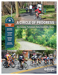
In March 2018, DVRPC developed a feasibility study to plan and analyze a network of multi-use trails and on-road bicycle facilities to create the Greater Pottstown Trails network. Cyclists of a moderate skill level will be able to use the completed network to more easily travel through Pottstown Borough and eight surrounding municipalities in Chester, Montgomery, and Berks counties. The study also prioritizes planning safe, scenic, and well-connected trails and on-road facilities for cyclists and pedestrians of different ages and skill levels. Residents will be able to reach important destinations within the multi-municipal area and major trails in the larger Circuit Trails network, including the Schuylkill River Trail and Perkiomen Trail.
The study focuses on the opportunities and challenges of constructing trails that municipal and county leaders and staff, together with recreation advocates, educators, and other stakeholders, have proposed for the region. It also provides basic construction phasing guidelines and recommends which trail segments should be designed and constructed first to move the network from the planning stage to construction.
The Trails
The Greater Pottstown Trails network is made up of four trails: the Coventry Trail; Pottsgrove Trail; Manatawny Trail; and West Trail, which the study divides into the Lower West Trail and Upper West Trail.
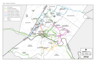
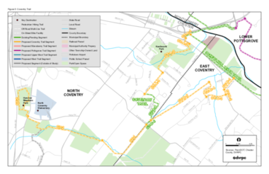
Coventry Trail
The Coventry Trail will connect North Coventry Township and East Coventry Township to the Schuylkill River Trail and other proposed trail networks that will ultimately link to French Creek State Park to the southwest. Between the forests in Kenilworth Park and the preserved farms to the south, the Coventry Trail will offer residents opportunities for a scenic walk or ride.
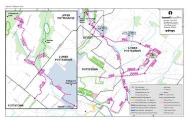
Pottsgrove Trail
The Pottsgrove Trail will be shared between Lower Pottsgrove Township, Upper Pottsgrove Township, and Pottstown Borough. It will further these municipalities’ ambitious plans for trail and bicycle facilities while also connecting them to the regional Circuit Trails network via the Schuylkill River Trail.
Manatawny and Lower West Trails
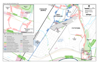
The Manatawny Trail, which will run through Pottstown Borough and West Pottsgrove Township, is a high priority trail for Montgomery County. The trail will provide a regional connection to the Schuylkill River Trail; a connection to Walk and Bike Pottstown, Pottstown’s bicycle and pedestrian network; and a pedestrian connection on the proposed Secret Valley Trail northwest into Boyertown.
The Lower West Trail, another high priority trail for Montgomery County, will run through West Pottsgrove Township and Pottstown Borough, and will connect to the Schuylkill River Trail and Manatawny Trail. Cyclists and pedestrians will be able to reach a variety of destinations, including West Pottsgrove Elementary School, Oldtimers Field, West Pottsgrove Pool, Pottstown Municipal Airport, the Colebrookdale Railroad, Murgia Park, and retail destinations in the Circle of Progress like Sly Fox Brewery.
Upper West Trail
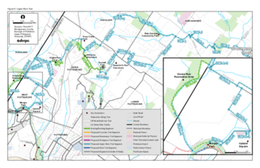
The Upper West Trail is the northern and longer section of the West Trail. It will run from West Pottsgrove Township northeast to New Hanover Township before reaching the proposed Sunrise Trail and West County Trail outside of the Greater Pottstown region. Cyclists and pedestrians using this trail will be able to reach the Upland Square Mall and eight parks.
Early Implementation Projects
One of the the feasibility study’s purposes was to help other partners prioritize the trail segments which will move through design phase and into construction. After considering a variety of criteria, the project team identified five sets of segments as early implementation projects.
Coventry Trail: Alternative A
“Alternative A” is a predominantly off-road multi-use trail with one sharrow segment. The segments' combined length is 1.45 miles. Located in North Coventry Township, they connect to the Schuylkill River Trail and pass through Kenilworth Park. These segments are discussed in greater detail on pages 19–20 of the study.
Pottsgrove Trail: High School to Hollenbach Park
The "High School to Hollenbach Park" segments are roughly equally divided between multi-use trail and on-road sharrows. The segments’ combined length is 1.26 miles. Shared between Lower Pottsgrove Township and Upper Pottsgrove Township, they connect Pottsgrove High School to Hollenbach Park across PA 663 (North Charlotte Street). These segments are discussed in greater detail on pages 33–37.
Manatawny Trail: Schuylkill River Trail through Memorial Park
The "Schuylkill River Trail through Memorial Park" segments are mostly multi-use trail with two sharrows segments. Their combined length is 1.04 miles. Located in Pottstown Borough, they connect to the Schuylkill River Trail and pass through Montgomery County Community College, the Gateway Tourism and Recreation District (TRec District), and Memorial Park. These segments are discussed in greater detail on pages 43–47.
Lower West Trail: Oldtimers Field to Murgia Park
The "Oldtimers Field to Murgia Park" segments are predominantly multi-use trail with one sharrows segment. Their combined length is 1.08 miles. Shared between West Pottsgrove Township and Pottsgrove Borough, they pass through Oldtimers Field and along the amenities on Circle of Progress Drive. These segments are discussed in greater detail on pages 53–54.
Upper West Trail: Murgia Park through Goose Run Recreation Area
The "Murgia Park through Goose Run Recreation Area" segments are all multi-use trail. Their combined length is 1.40 miles. Shared between West Pottsgrove Township and Douglass Township (Berks County), they pass through the Goose Run Recreation Area. These segments are discussed in greater detail on pages 64–65.
How is the Study Being Used?
DVRPC’s partners on the Steering Committee are using the study to develop more detailed engineering drawings to design, and eventually construct, the four trails in the network.
DVRPC staff refer to the study when evaluating transportation projects in the Greater Pottstown area to see if they might help or hinder the development of the trail network. DVRPC also shares the plan, as well as its maps and data, with partners that request it.