Transportation Operations and ITS Planning
Transportation Operations Task Force (TOTF)
The Task Force is a forum for agencies to share information on ITS deployments and incident management programs, develop a consensus on regional ITS issues, respond to federal initiatives, and develop an annual action plan. It has the ability to establish subcommittees to tackle specific issues as they arise. As a technical-level group, it directs DVRPC's Transportation Operations planning activities that in turn support the Task Force.
DOT Operations / ITS Initiatives
PennDOT Regional Operations Plan (ROP) - DVRPC Region District 6
The PennDOT District 6-0 Regional Operations Plan was developed for PennDOT to address the transportation operations in the DVRPC region. At the statewide level, PennDOT adopted the Transportation Systems Operation Plan (TSOP), in September 2005, to define operations needs and set direction for the agency. A ROP was then developed for each region in the state to delineate local needs and direction. ROP products are to feed the local TIP, the regional ITS architecture, and the TSOP.
An extensive stakeholder process identified four priority needs areas:
- Incident and event management - Strengthen relationships between transportation agencies and incident responders. Improve capabilities for detection of incidents. Initiate comprehensive policies and procedures for incident response.
- Traveler information - Expand deployment of current traveler information systems. Expand partnerships with information service providers and the goods movement community.
- Corridor and congestion management - Deploy ITS on Interstate highways to fill in current coverage gaps. Create an asset management system for traffic signals and system interconnects. Optimize traffic signal timings at intersections and along corridors. Develop programs to prioritize signal system upgrades and signal optimization. Build upon the regional fiber communications network.
- Institutional coordination - Complete implementation of RIMIS. Establish a greater consistency in information sharing.
Working with ROP stakeholders, a preliminary list of projects were developed for each needs area. The projects were categorized as to their implementation timeframe, and then prioritized within each category. Below are the top ten short-term and long-term priority projects, in descending order of priority.
Short-term projects:
- I-95 ITS deployment from Delaware State Line to airport
- Emergency service patrol coverage, Phase I
- Philadelphia last mile fiber connections
- Completion and implementation of RIMIS
- Develop Regional Strategic Corridor Investment Plan
- Strategic Arterial Corridor Signal Inspection and Revision Program
- Strategic Arterial Corridor Signal System Upgrade Program
- Establish incident management task forces
- Fiber connection to DelDOT
- Continue to update and provide PennDOT detour routes via the internet
Long-term projects:
- I-476 ITS deployment from I-95 to Pennsylvania Turnpike
- I-95 ITS deployment from Island Avenue to Vine Street
- I-95 ITS deployment from US 1 Business to New Jersey State Line
- Emergency service patrol coverage, Phase II
- Fiber connection to select Pennsylvania State Police barracks
- Construction of traffic operations center for Philadelphia Streets Department
- Fiber connection to NJDOT
- Construction of traffic operations center for DRPA
- Parking management system for select SEPTA facilities
- Parking management system for Philadelphia International Airport
Download the Regional Operations Plan (ROP) - DVRPC Region District 6 [0.7 MB]
NJDOT ITS Investment Strategy
NJDOT's Intelligent Transportation Systems Engineering supports statewide traffic operations by managing the development, implementation, and support for ITS initiatives. These initiatives include the Statewide Traffic Operations Center, integrated traffic signal systems, incident management systems, traffic management systems, traffic information systems and other ITS components.General information regarding the NJDOT'S overall ITS plan is provided in the ITS 10-Year Investment Strategy, which included the
- Goals and Budget for Operating and Enhancing ITS
- Priority Corridors
- Summary and Projected Benefits
Download the NJDOT ITS Investment Strategy [0.6 MB .pdf]
Intelligent Transportation System Technology
ITS represents an array of new technologies that monitor travel conditions to convey information to travelers. Within the Philadelphia area, NJDOT and PennDOT traffic operations center personnel, using TV cameras, monitor traffic conditions and instantaneously notify motorists of delays through overhead variable message signs; if the congestion resulted from an accident, police and medical personnel are notified. Highway and bridge toll authorities deployed E-Z Pass to speed travel though toll plazas, allowing motorist to use a common toll payment medium instead of worrying if they have exact change. Using GPS systems, SEPTA monitors their bus fleet, determining which buses are behind schedule and taking corrective actions as needed. Burlington County installed closed loop systems allowing county traffic engineers to change signal timing patterns in real-time to reflect traffic conditions, minimizing stops and delays for motorists.
Below are examples of ITS technology deployed in the region.
Traffic Operation Centers
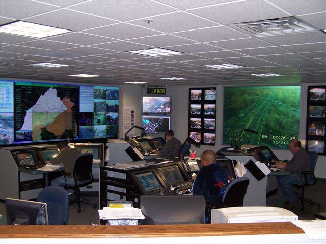
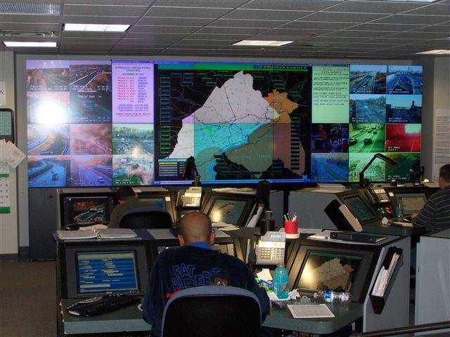
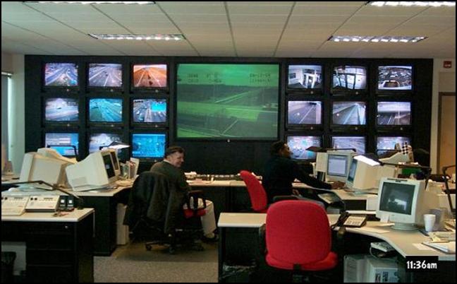
Traffic Operation Centers are the focal point of traffic management and incident management systems. Traffic operation centers have the capability to monitor closed circuit television images and traffic flow sensors, operate computerized traffic signal systems, variable message signs, highway advisory radio, manage emergency service patrols and coordinate incident management response teams. While the equipment in each operating center varies by agency, the typical operations center consists of any number of computer workstations, police and fire radio scanners, video walls displaying highway images, audio text recording booths (for highway advisor radio messages), and a communication room where feeds from field equipment come into the operations center. In the Philadelphia region, some of the agencies that employ traffic operations centers include NJDOT, PennDOT, New Jersey Turnpike, Pennsylvania Turnpike, and Burlington County. PennDOT's Traffic Management Center, located in King of Prussia, is the primary coordinating point of District 6-0's traffic operations for the five-county Pennsylvania portion of the region. Pictured are different views of PennDOT's Traffic Management Center and NJDOT traffic operations center.
|
|
|
|
Closed Circuit Television (CCTV) Cameras
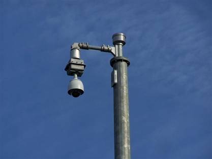
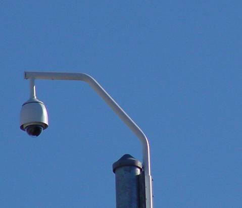
Highway CCTV cameras are located on roadways where accident rates and/or congestion levels are known to be high. Traffic operations center personnel monitor real-time video feeds, identifying accidents, disabled vehicles, and other unusual conditions so that response personnel are dispatched as soon as possible. PennDOT video is shared with county 911 call centers, allowing them to confirm reported incidents and helping them determine the appropriate type of equipment to send to the scene. Many agencies post their video on their traveler information websites. The pictures show views of surveillance cameras in the DVRPC region.
|
|
|
Roadway Detectors
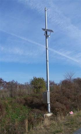
Roadway detectors collect information on vehicle speeds, travel times, traffic volume, and vehicle classification data (i.e., number of trucks and cars). Depending upon its application, roadway detectors typically use radar or video imaging technology. Traffic flow information is used to detect incidents on highways, and adjust traffic signal timing at intersections. Highway agencies are increasing usage of detector information to post travel times on variable message signs, Traffic.com disseminates travel times via text messaging, cell phones and its website. Pictures show different roadway technologies deployed in the region.
Variable Message Sign (VMS)
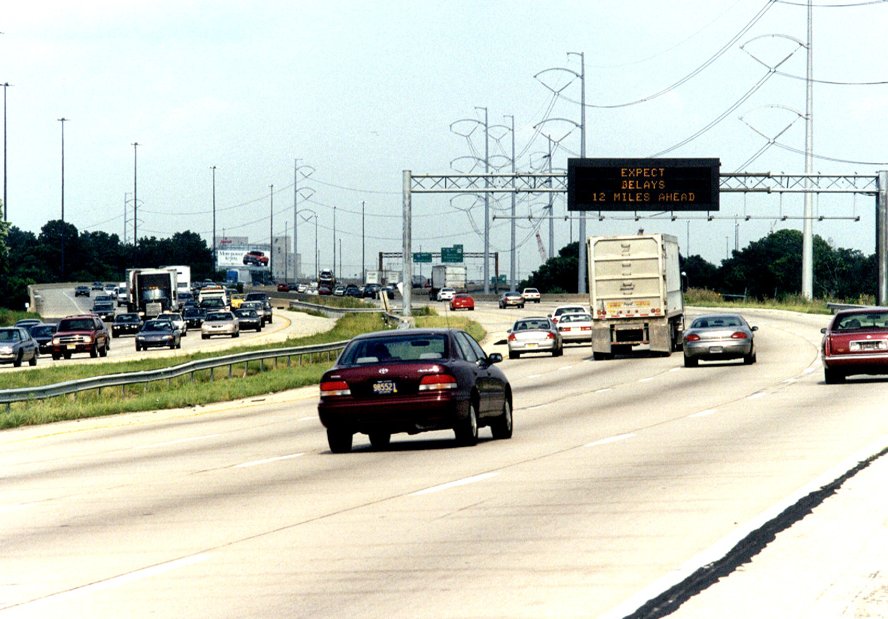
The purpose of variable message signs is to provide real-time traffic advisories to motorists. Alerts are generally restricted to traffic accidents, delays, or maintenance and construction activity. Highway agencies are increasing posting real-time travel time information on the signs. Variable message signs are either centered over travel lanes, or placed alongside the roadway. Most signs only have two or three lines for information, thus the wording is very limited. Messages originate from a traffic operations center, and are transmitted to the sign via fiber optic cable or a telephone connection. The picture is a variable message sign on Northbound I-95 near the Philadelphia International Airport.
Highway Advisory Radio (HAR)
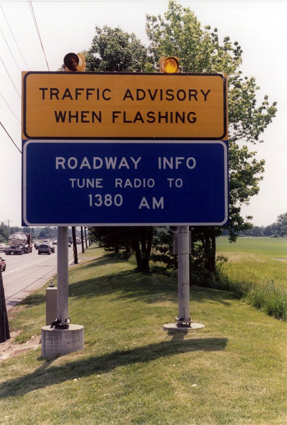
Highway advisory radio stations provide motorists with real-time roadway information, weather information, agency hotline numbers, incident information, roadway construction advisories, etc. The FCC reserves certain AM and FM frequencies for public agencies to broadcast travel advisories using low power transmitters. The New Jersey Turnpike, for example, uses 1610 AM to broadcast information catered to its roadways. The pictures show a highway advisory radio traveler advisory sign, used to notify motorists to tune into an alert.
Traffic Signal Systems
Traffic signal systems control a group of adjacent traffic signals on the surface street network. Through the use of sensors, a centralized computer monitors traffic flow and determines the master signal timing pattern; local controllers then optimize traffic flow at individual intersections. Signal systems are employed on arterial highways and grid networks found in business districts Benefits of traffic signal systems include reduction of stops, travel times, and accidents, and increases in average travel speed and vehicle flow. Consequently, they produce fuel savings and lower vehicle emissions. The pictures show traffic signals with video detectors used to measure traffic flow on signal approach lanes.
Traffic Signal Preemption
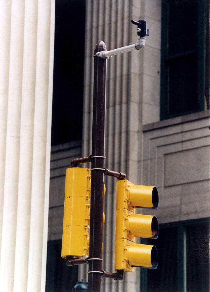
Traffic signal preemption technology allows both transit and emergency vehicles to send direct control requests to signalized intersections. These messages result in preemption of the current signal control plan and grants right-of-way to the requesting vehicle. In this region, most applications of traffic signal preemption have been for emergency vehicles. However, the City of Philadelphia and SEPTA have implemented a number of projects for transit vehicles. The picture shows a signal preemptor at a signalized intersection on Chestnut Street in Center City Philadelphia.
Electronic Toll Collection (E-ZPass)
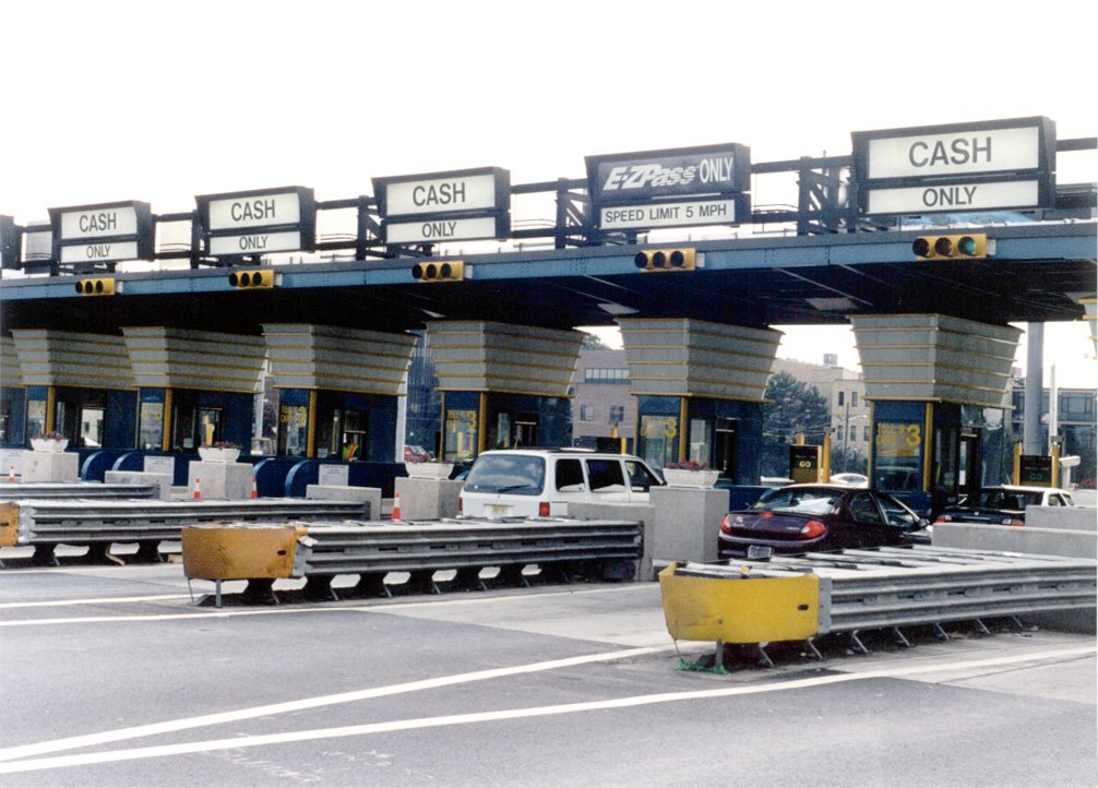
Benefits of electronic toll collection include less congestion at toll plazas, improved air quality and increased convenience for motorists. E-ZPass was developed by a consortium of toll agencies located in the northeast United States. When a vehicle passes through an E-ZPass designated toll lane, an electronic tag (in the form of a small box mounted on a vehicle windshield) is detected by an antenna and the appropriate toll is deducted from the customer's prepaid E-ZPass account. E-ZPass is deployed on all toll bridges and toll roads in the region. Several toll authorities are constructing high speed E-ZPass lanes to move traffic through the toll barrier at mainline speeds. The pictures show E-ZPass lanes at the Ben Franklin Bridge toll plaza.
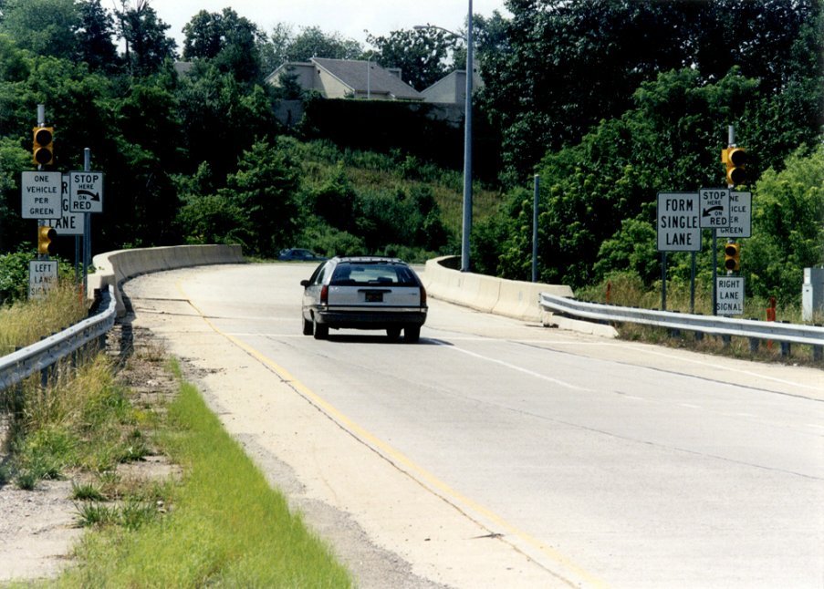
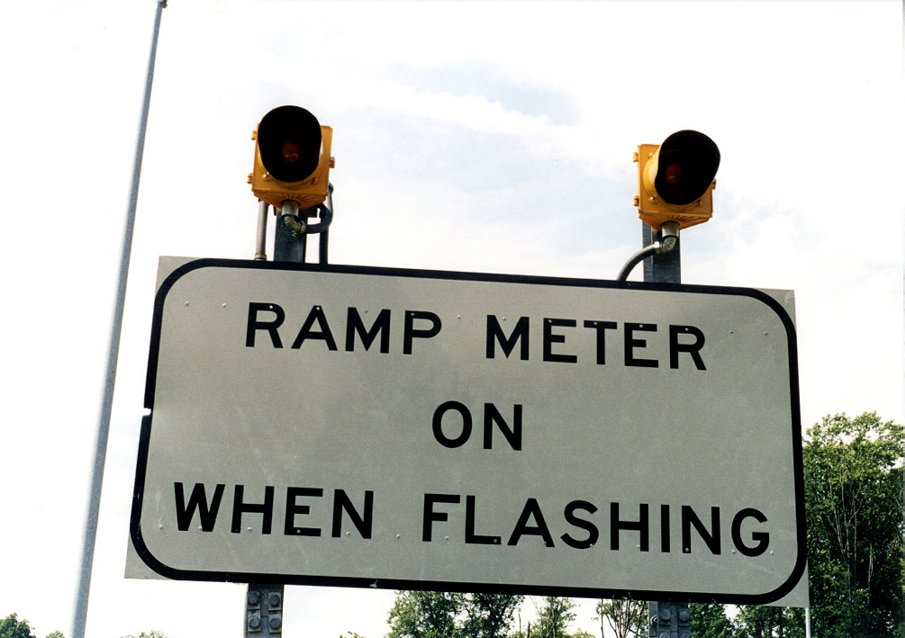
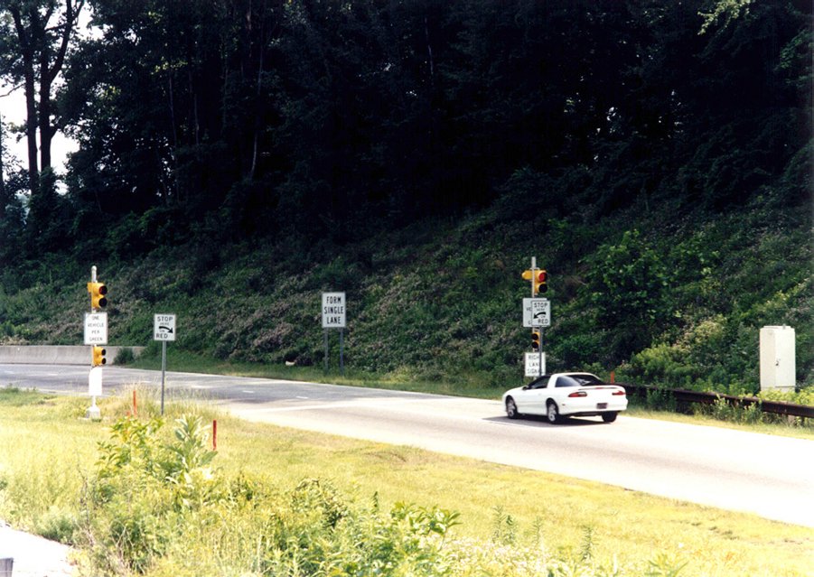
Ramp Metering
Ramp metering is designed to control the rate of traffic entering a freeway. The objective is to maintain a predetermined level of service on the freeway by adjusting the on-ramp traffic volume with a traffic signal. Typical waiting times at ramp metering signals are between 5 to 6 seconds per vehicle. The pictures show a local ramp metering configuration for an on-ramp to I-476, the only highway in the region where ramp metering is employed.
|
|
|
|
Commercial Vehicle Operations
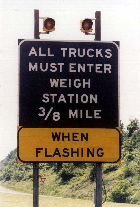
Commercial vehicle operations cover a wide range of services, including commercial driver licensing, vehicle registration, vehicle inspection, weight limitations, and motor vehicle taxes. ITS will automate many services with one-stop shopping for drivers licensing and registration, and transponders to identify vehicles in order to assess motor vehicle taxes. Weigh stations will utilize weigh-in-motion (WIM) technology, which uses automatic weight measuring equipment (fixed sensors embedded in the pavement) to calculate the weight of a commercial vehicle at highway speeds to ensure the vehicle is operating within predetermined safety limits. Presently, commercial vehicles must pull over to a weigh station located on the side of the highway.
Transit Control Centers
New Jersey Transit, PATCO and SEPTA all have operation centers to manage their transit activities. SEPTA's operation center, the most advanced transit control center in the region, primarily functions as a command/control point for Regional Rail Operations, City Bus and Rail Operations, Suburban Bus and Trolley Operations and SEPTA Transit Police. Operation center staff has the ability to monitor the transit system, on wall sized video displays, and reroute trains and buses as needed. Supervisory Control and Data Acquisition (SCADA) systems are used to monitor and control many elements of SEPTA's operations including buses, and rail signal and power systems. When a train or bus needs service, the center notifies a line or street supervisor respectively to investigate and manage the situation. The control center can issue travel alerts via public address systems and dynamic message signs in stations, or on SEPTA's website and interactive phone system. The pictures show various elements of SEPTA's control center.
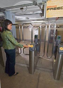
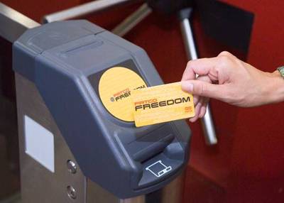
Smart Card Fare Collection Systems
Smart cards are an advanced payment media slowly being rolled out by transit agencies. They are pocket-sized plastic cards embedded with integrated circuits which can store and process fare information. A contactless form of smart card permits passengers to go through a turnstile without needing to swipe a card. Smart cards offer multiple benefits. Passengers will be able to purchase cards with credit cards, reducing the need to carry cash; smart cards can be used for multiple purposes, pay for parking at transit stations or purchasing goods from stores. For transit agencies they reduce fare collection costs because there is no need for token booths, cards are purchased through vending machines; since there is less cash involved, there is less need for revenue collection personnel; and contactless technology reduces turnstile breakdowns. PATCO's Freedom Card is the first transit smart card issued by a local transit agency.
|
|
|
Dynamic Message Signs (DMS)
Dynamic message signs are very similar to variable message signs, but displaying train information. As transit agencies deploy technology to more accurately track their transit fleet, their operations centers are now able to automatically post information on train arrival times at stations. The appearance of dynamic signs varies greatly. PATCO uses scrolling LED displays, while SEPTA use more traditional display boards. SEPTA is also experimenting with smart bus stops, providing real-time arrival times at bus stops.
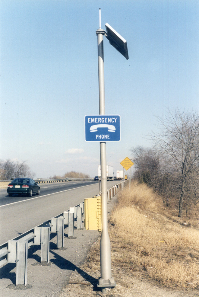
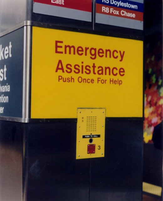
Emergency Call Boxes
Emergency call boxes allow travelers who do not have cellular phones to report accidents and other emergency situations. It is applicable to both highways and transit. The Atlantic City Expressway and Pennsylvania Turnpike have call boxes located along the side of their roadways. SEPTA and PATCO employ call boxes at their stations. The picture shows an emergency call box at SEPTA's Market East Station.
|
|
|