DVRPC News: February 2013
Volume 34, Issue 8
February 2013
New Smart Growth Website a Valuable Resource for Stakeholders
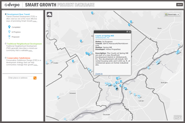 DVRPC has launched a new interactive mapping application that tracks a variety of noteworthy development projects throughout the Greater Philadelphia region. The Smart Growth Project Database focuses on three types of Smart Growth projects: developments near transit, traditional neighborhood developments (TND), and conservation subdivisions.
The website – which includes projects that are proposed, in progress, and complete – is meant to serve as a valuable resource for municipal officials, planners, and citizens interested in learning more about Smart Growth efforts around the region. For more information, contact Andrew Svekla at asvekla@dvrpc.org or 215-238-2810.
The website is now live and can be found at www.dvrpc.org/webmaps/SGDP.
Project to Improve Traffic Modeling Nearing Completion
 DVRPC is nearing the end of its VISSIM Standards Project. The two-year project will improve micro-scale traffic operations simulation (focused primarily on the VISSIM modeling software) in the DVRPC region. The results will save time and money on many future projects by reducing data collection needs, as well as improve the accuracy of the models by providing default input values from a smaller geographic area. The results of the first year's analyses were summarized in VISSIM Standards Project: Summary of Year One Findings while the results of the second year are forthcoming.
Staff assembled an advisory committee comprised of many of the region's VISSIM users, including those from other public agencies as well as from the region's consulting firms. The advisory committee was charged with recommending specific measurements and vetting results. During the first year, staff developed free-flow speeds – or the speed motorists travel when unimpeded – for various road and geographical contexts, values regarding traffic signal efficiency for various road and context types, and quantified driver behavior at stop-sign controlled intersections where most drivers do not come to a complete stop.
Three additional measurements were selected for the second year, including the development of default vehicle composition profiles for various road and context types, quantifying heavy vehicle speed reduction on steep slopes, and the development of default standstill distances meaning the distance between queued vehicles. The results of this project will improve microsimulation modeling conducted by DVRPC staff and other VISSIM users in the region by enhancing traffic analysis for years to come.
For more information, contact David Anderson, Manager, Office of Transportation and Corridor Studies, at 215-238-2825 or danderson@dvrpc.org.
Operational Improvements for the I-76 and I-476 Interchange
 At the conclusion of the Schuylkill Expressway (I-76) Operational Research Model project, PennDOT directed that the modeling tools be made available to member agencies for local application and that DVRPC be responsible for administering and maintaining the models. There is a new project in the works where the I-76 Operational Research Model will be used to measure how the improvement of three consecutive I-76 eastbound on-ramps through the I-476 and Conshohocken interchanges would affect performance.
It is likely that these changes would significantly improve mobility along the mainline of I-476 southbound and I-76 eastbound through the interchange. Traffic operational analyses using the VISSIM models from the Schuylkill Expressway Operational Research Model project will be conducted during the AM Peak and PM Peak periods when the traffic volume is high, and the Midday Trough period when the traffic volume is lower. These time periods will be evaluated in depth to determine the advantages and disadvantages of the proposed improvement.
Performance changes will be calculated for the current condition of the interchange; the Year 2035 Long-Range Plan (No-Build Condition), where only committed changes to infrastructure are made; and the Year 2035 Long-Range Plan (Build Condition), assuming that recommended changes to infrastructure are implemented. Performance measures to be compared and contrasted between scenarios will include traffic volumes, average operating speeds and travel times, queue lengths, delay, and density.
For more information, contact David Anderson, Manager, Office of Transportation and Corridor Studies, at 215-238-2825 or danderson@dvrpc.org.
Transforming Open Space to Sustainable Farm Enterprises
 GreenSpace Alliance, with assistance from DVRPC, has launched a new project: Transforming Open Space to Sustainable Farm Enterprises. The GreenSpace Alliance (GSA) is a non-profit organization that advocates for and promotes the preservation and stewardship of natural resource, agricultural, and outdoor recreational lands in southeastern Pennsylvania.
GSA recognizes the integral role that open space plays in a healthy society. This report examines the potential use and benefits of transforming preserved open space that is not currently farmed, into sustainable agricultural enterprises in southeastern Pennsylvania. The findings conservatively estimate that sustainable agricultural enterprises on a small portion of the region's protected parkland, utility corridors, and Philadelphia's vacant lots could generate nearly $258 million annually in crop value in the five-county region. Thus, advancing sustainable agriculture enterprises in southeastern Pennsylvania has the potential to create jobs and add to the local, grass-roots economy while supplying additional fresh, nutritious food to the region's population. The report also includes recommendations for overcoming logistical and funding obstacles to increased sustainable farming.
Download the brochure or full report here and contact Patty Elkis, DVRPC Deputy Director of Policy, Planning and Programs at pelkis@dvrpc.org for more information.
Mark Your Calendars
 DVRPC is hosting a special public meeting on Thursday, March 7, 2013 at 6 PM at the Lansdale Library, Lansdale, PA.
This meeting is part of a series of listening sessions held around the region. The goal of the meeting is to reach residents, businesses, municipalities, organizations, and other stakeholders in the Greater Philadelphia region to inform them about DVRPC and public participation activities in the regional planning process.
In addition, Ted Dahlburg, Manager of DVRPC's Office of Freight and Aviation Planning, will present on various topics related to freight planning in the region. Since 1992, DVRPC has been conducting freight planning on a continual, comprehensive, and coordinated basis. This Regional Listening Session will focus on how freight planning impacts the land use and economics of the Greater Philadelphia area.
DVRPC staff looks forward to your participation. To RSVP, or if you have any questions, please contact Jane Meconi at 215-592-1800 or public_affairs@dvrpc.org.
HOP Training for Municipalities
 Need to alter a driveway or road that falls within State highway right-of-way? The Highway Occupancy Permit (HOP) process does not need to be confusing or difficult. PennDOT is partnering with municipalities to encourage well planned and safe community growth through a training session. This two-hour introductory session includes two modules: (1) the basics of HOP's – including access location selection and smart access design; and (2) walking through the e-permitting process highlighting the municipality's role and an upcoming "Municipality Portal" that will provide local governments direct access to key HOP information.
The presentation is geared toward public officials and those directly involved in the reviews of subdivision and land development plans. Participants in the training will be provided with the tools necessary to participate in the Municipality Portal when it becomes available later in 2013. Attendance is limited to approximately 30 participates on a first-come, first-served basis.
Sessions will be held at the following locations:
Thursday, February 28, 2013
12:30 PM Registration
1:00 PM – 3:00 PM Session
Warwick Township Building
1733 Township Greene
Jamison, PA 18929
Wednesday, March 6, 2013
12:30 PM Registration
1:00 PM-3:00 PM Session
Chester County Planning Commission Building
601 Westtown Road
Board Room, Suite 270
West Chester, PA 19380-0990