2030 Greenspace Network
The 2030 Greenspace Network links existing parkland, population centers and key natural resource areas worthy of preservation into a unified system. Linking "green spaces" throughout the region boosts their recreational, ecological, scenic and economic value. Greenspace is a form of public infrastructure necessary for community health, function and sustainability.
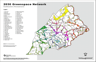
2030 Pennsylvania Greenspace Network Map [1.0 MB .pdf]
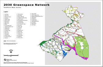
2030 New Jersey Greenspace Network Map [0.7 MB .pdf]
The Greenspace Network is based on the twin principles of protecting core natural open space areas and linking them with greenways. The Network proposes to protect large expanses of unprotected woodlands, stream corridors, wetlands, meadows, vacant lands, and in some cases, agricultural lands, and join them with existing parks to create an inter-connected system. Most Pennsylvania Natural Diversity Index (PNDI) sites are included in the network, as are New Jersey's Natural Heritage Priority Sites. The Greenspace Network also includes nearly all significant natural areas proposed for protection by county open space and greenway plans.
The Greenspace Network enhances ecological and recreational capacity, protects critical natural resources, ameliorates the impacts of sprawl, and improves the quality of life in the region's communities. Each of the 100 greenspace corridors in the Network is named to promote its identity and brand it as a unique preservation project.
Given the regional scale of the map, the proposed network is somewhat generalized, but it serves to create a framework for state, county and municipal preservation plans. More detailed mapping at the local area scale is recommended to determine specific boundaries and priorities. The proposed Greenspace Network is aimed at achieving the following specific objectives:
- The protection of woodlands and other upland habitat areas that provide an environment for the diverse plants and animals of the region, particularly those areas identified as containing threatened and endangered species.
- The protection of river and stream corridors, floodplains, and wetland areas that provide clean water for drinking, habitat for fish, plants and other wildlife, and recreational opportunities. Buffers varying from 25 to 300 or more feet wide are recommended to maintain vegetation, provide habitat, control stream temperatures, reduce erosion, and filter non-point runoff to protect water quality. In certain areas, these stream corridor buffer areas may also accommodate scenic paths or other recreational access for fishing or boating or increase other waterfront access uses.
- The protection of other unique natural resource features of the region that may represent a notable ecosystem, geologic formation, or habitat area. In many cases these areas contain unique, threatened or endangered plants or animals and may be inappropriate for recreational or other access.
- Providing lands for the construction of trails and paths that connect and provide access to existing parks, streams, woodlands and population centers. This system of trails and greenways can provide access to a variety of different but connected resource areas.
- Provision of additional land for recreational activities, with those recreation activities matched to the appropriate resource. For example, while many upland areas are suitable for passive recreation activities, sensitive resource areas in the region should be protected for their ecological value and may not be appropriate at all for recreational use.
- Finally, open space in the region serves a valuable function for its visual aesthetic, the scenic vistas and opportunities for relief from the man-made that connects people to the natural environment. In many ways, it is the ongoing presence of a stream valley, hillside or favorite woods that act as an identifier of home, or "sense of place". In urban areas, these remaining natural areas or efforts to return natural elements such as Philadelphia's Street Tree Program are particularly critical. Additional open space in urban areas such as community gardens also provide an important neighborhood stabilization role.
Although the proposed Greenspace Network is generalized at the regional scale, it can also provide quantitative goals for open space protection to which each county's progress over time can be measured. The following table presents the acres of greenspace in need of protection to achieve the 2030 Greenspace Network goals:
| County | Protected Greenspace Network Lands (2004) | Unprotected Greenspace Network Lands | All Greenspace Network Lands as % of Total Area | Annual Acres Needed to Meet 2030 Goal |
| Bucks | 39,182 | 73,910 | 29.1% | 2,956 |
| Chester | 52,561 | 83,493 | 28.1% | 3,340 |
| Delaware | 11,739 | 17,997 | 25.2% | 720 |
| Montgomery | 26,846 | 48,010 | 24.2% | 1,920 |
| Philadelphia | 10,664 | 8,886 | 22.6% | 355 |
| PENNSYLVANIA | 140,992 | 232,296 | 26.9% | 9,292 |
| Burlington | 159,048 | 113,322 | 52.9% | 4,533 |
| Camden | 25,554 | 29,251 | 38.5% | 1,170 |
| Gloucester | 11,587 | 37,986 | 23.8% | 1,519 |
| Mercer | 22,713 | 16,656 | 27.2% | 666 |
| NEW JERSEY | 218,902 | 197,215 | 41.2% | 7,889 |
| REGION TOTAL | 359,894 | 429,511 | 33.0% | 17,180 |
| % of Total Area | 15.0% | 17.9% | ----- | ----- |